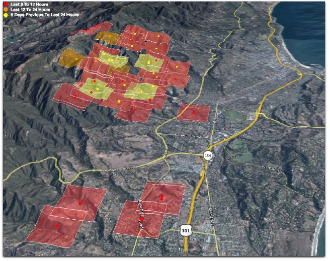
The shot above, a screen capture of a Google Earth view, with a .kml overlay from MODIS, shows the first fire detections (that I’ve seen at least), south of Foothill/Cathedral Oaks and west of 154. It also shows the first detections across the spine of the Santa Ynez Mountains. 3:02am. (All times Pacific.)
These detections do not mean fire spreading. During the Tea Fire, there were many detections that didn’t spread, at some distance from the fire itself. Still, this map gives a good visualization of the growing fire perimeter. 3:03am
KEYT/3’s 3:00am video report. 3:04am
Far as I know, only KTYD is covering the fire live right now, at 3:10am. All the talk is about evacuations. Nothing about homes burning. KTYD’s four sister stations are also carrying the same audio. Click on “Listen Live” on the website. 3:13am
The latest from the Independent:
The fire is only a few hundred yards from Foothill in the San Roque area, but doesn’t appear to be burning any houses at the moment thanks to the firefighters concerted effort to hold Foothill Road.
Firefighters extinguished a small spot fire at Steven’s Park and trying to save homes at Canyon Acres off Ontare. One structure is already burning there; firefighters requested three to four extra engines to protect approximately 12 houses. 3:28am
Collected Independent coverage. 3:28am Copied from a byline: Ray Ford, Matt Kettmann, Chris Meagher, Ben Preston, Nick Welsh. These guys are doing a great job. Near as I can tell, the Indy is the only news organization with reporters working the fire around the clock. Outstanding work.
Hats off to Edhat as well. There are 328 comments so far to Ed’s latest report. 5:32am
From among the Edhat comments, this collection of GOES-10 satellite photos. Interesting to see where the smoke goes. 5:35am
John Wiley has lots of photos. 5:41am
I listened to the first three or four speakers in the 8am press conference, and then made the good chap I had an appointment with wait while we both listened to see if anybody would say what listeners most wanted to hear: what homes were lost, and what homes were most in danger. I hate to be critical of people doing heroic and much appreciated work, especially when it is quite true — as these speakers said — that many more homes were saved than lost, and at great risk and effort. I’ll just say it was frustrating not to get specifics about homes. Maybe they came around to it eventually. I don’t know. Eventually I had to turn off the radio (actually an iPhone tuned to KTYD) and get on with my meeting.
On the positive side, dig what Matt Kettmann (Contact), Sam Kornell , Ben Preston (Contact), Ethan Stewart (Contact) of the Independent wrote in Assessing What’s Burned: Damage Report, Updated Friday:
Although the task can be difficult in a wildfire zone — especially one with as many twists, turns, and long driveways as the foothills of Santa Barbara — The Independent’s reporters are trying their hardest to deliver what everyone who’s evacuated wants to know: the addresses of homes that have not survived the Jesusita Fire.
And deliver they do. First, the disclaimer:
We are fully aware that mistakes in this sort of reporting could be horrible for homeowners who get the wrong information, so we’ve strived for the utmost accuracy. Furthermore, based on responses we’ve already received during this fire and others, we believe that this public service is one of our most valuable roles as a media entity, and hope you find the information useful.
As of 1:30 p.m. on Friday, the following is what The Indy’s team of reporters has been able to put together.
Then the list, with very careful qualification. Excellent stuff. If the Indy doesn’t get an award for its fire coverage, there is no justice in Officialized Journalism.
Here is a recent Google Earth shot with a MODIS overlay of fire spottings by satellite. Note the difference between this one and the shot at the top from early this morning:
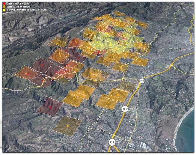
The nearest red spot is above San Jose Creek in the canyon above Patterson Ave, near some orchards or vineyards. This is in or below the area burned by the Gap Fire in July of last year. Perhaps more scary is the set of new red squares advancing northwest toward Painted Cave, which is on the left edge of this shot. Here’s a better view:
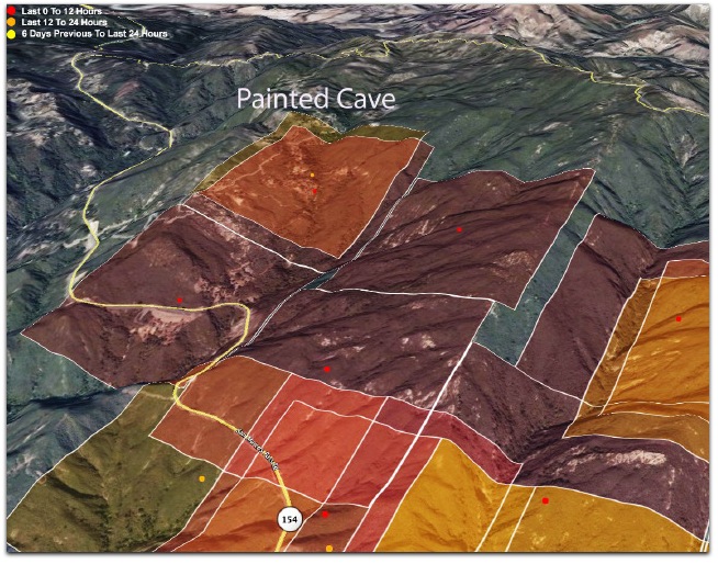
The last big fire in Santa Barbara — and the biggest ever in terms of home loss — was the Painted Cave Fire of 1990. More than 600 homes were lost. But none in Painted Cave itself. The fire started near there, but advanced straight down toward the sea. Many of the houses you see on this picture between the 101 and 154 symbols on this shot were burned in that fire. 5:09pm
There’s a press conference going on. I’m listening on KNX/1070. Also KCLU/1340/102.3. The KCLU stream (which is what I’m now listening to, here in Boston) is here. 5:14pm.
30,500 are evacuated. (That includes us, by the way. We’re kind of extremely evacuated, staying about 3,000 miles away.) “There will be no re-population tonight.” Shelter is available. Room left at the Multi-Activities Center at UCSB. Find it off Mesa. “A supurb evacuation center.” Special needs folks should go to the Thunderdome on the campus. KCLU is summarizing now. KNX continues to carry the audio of the conference. Surprising since KNX is a Los Angeles news station that covers all of SoCal, and needs to run advertising every few minutes. So they’re eating that income. KCLU is back to its regular NPR program. 5:22pm
Inciweb has a Jesusita Fire incident page now. For earlier fires, Inciweb has been the canonical (if unofficial) source of data. KNX just directed listeners looking for non-Santa Barbara news to KFWB, its sister station in Los Angeles. KNX has a strong signal in Santa Barbara. KFWB has none and is much more local to L.A. itself. 8:27pm
They’ve been using “multiple arial assets” including a DC-10 that can deliver large payloads.5:32
Getting close to posting addresses and other “assessments”. “Confident we’re moving towards” posting those. In the next two days. Close to 2500 personnel. More than 200 fire engines. Massive mutual aid program. 5:33pm
Can somebody ask about Painted Cave? 5:34pm
Pictures from Mercury Press. 5:40pm
Ray Ford has another excellent piece in the Independent. To answer a commenter, below, Cocopah was okay. Ray names names on other streets as well. 7:31pm
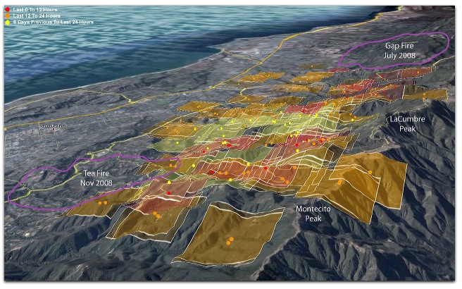
Here is a view toward MODIS fire findings. I’ve added Gap and Tea Fire perimeters as well. When this thing is over, we’ll have a charred mountain face, but not a bad fire break. For a short while, anyway. 7:38p
Okay, that’s enough pictures for your browser to suffer. I’m heading for bed. It’s 10:39 here and I need to be up early. 7:39pm
Leave a Reply